DIY Drones Are Coming: Assemble in 30 Minutes, Use It for Almost Anything You Can Imagine

If you have about $1,000 to spare and just want to take videos of things from the sky, then you should get a consumer drone. But if you want a drone that can hear, smell, or play laser tag, you’ll have to build one yourself. Thanks to a new drone kit from a startup called Skyworks, that’s not as hard as it sounds.

“Drones can be more than just flying cameras,” Skyworks says on its Kickstarter page for the project, called Eedu. Jinger Zeng, Skyworks’ chief operating offer, told Quartz that they want to encourage makers to build drones that explore all five senses.

Like many Ikea assembly projects before it, you only need an allen wrench and some patience to build an Eedu. Zeng says it takes about 30 minutes to put the drone together: “We want to take the complexity of robotics out of it, but still get the gratification of putting a drone together.”

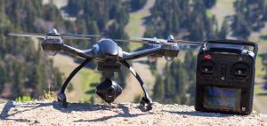
The more established drone companies are also saying their newest products are “platforms.” Both DJI and 3D Robotics have developer platforms for their high-end drones, but the drone hardware is still limited to cameras with propellers. The Eedu base model doesn’t come with a camera because Skyworks wants its users to experiment with other sensors.

Eedu puts the control of its drones, and what they can do, in the hands of the users. Once it’s built, the Eedu can fly right away, like any other commercial drone. But anyone can write code to make an Eedu do whatever they want. Rather like MakerBot’s repository of models for 3D printers, or GitHub’s library of code for developers, Skyworks wants the programs that users create for its drone to be an open repository. This means whether you’re an expert coder or not, and you see a neat program that someone has created for Eedu, you can download it and run it on your drone.

Skyworks created a drone laser tag game to show what sorts of things you can code for the Eedu. But Zeng envisions myriad uses for the drone: you can add a methane sensor to turn your drone into a coal mine canary; add a Geiger counter to detect radiation; add a heat sensor so firemen can detect where people are instead of entering an inferno themselves; or perhaps make an autonomous drone from scratch.

Eedu is compatible with open-source sensors, like those from SeeedStudio and LittleBits, meaning if something can be sensed, you’ll be able to make a flying version of it. Zeng said that the designs of Eedu’s parts will also be open-sourced, meaning that “people can 3D-print their own frame or do their own 3D customized design if they want.”

Skyworks is launching the Eedu on Kickstarter, but wants to use the drones to help shape its enterprise products of the future.

(As for the viability of this project—an important question, considering many broken Kickstarter-gadget promises—the company identifies itself as a startup composed of “recent college graduates” who have “collaborated together on various projects.” Its first drone has been on sale since December 2014.)

If the campaign is successfully backed, the Eedu team expects it to go into production in September and ship in January 2016. Eedu costs $449 during the pre-order period, or for $399, you can donate a drone for a student.

Micro Drone 3.0 Shoots HD Video Stabilized by a Mini-robotic Gimbal

Small, palm-sized quadcopters have a certain appeal within the increasingly cramped drone market. They are portable, low-risk and generally an inexpensive way for rookie pilots to learn the ropes. But these pint-sized robots have their shortcomings. In developing its new Micro Drone 3.0, UK company Extreme Fliers has set out to work features typically found in high-end drones into a smaller package, namely HD video stabilized by a tiny gimbal and compatibility with Google cardboard VR for first-person view flying.

Extreme Fliers is no stranger to the drone game. Its preceding Micro Drone 2.0 was designed as a low-cost beginner quadcopter capable of grabbing acceptable captures at 640p. But the latest iteration is promising quite a bit more.

Launched today on Indiegogo, the Micro Drone 3.0 shoots video at 720×1280 at 30 fps stabilized by what the company claims to be the world’s smallest gimbal. The palm-sized Zano drone we covered late last year also shoots at 720p and promises digital image stabilization, like that seen in more expensive Parrot Bepop. But as for steadying shots by way of minuscule robotic arms, the Micro Drone 3.0 appears to be flying solo.

The available sample footage looks to be halfway decent, but it will be interesting to see how it handles various lighting conditions and how steady the shots remain in practice. To aid these ambitions further, the company has developed special algorithms aimed at allowing the 71g (2.5oz) drone to handle rough winds of up to 45km/h (28mph).

The Micro Drone 3.0 can be controlled with a radio controller or an iOS or Android device by way of a companion app. The handy thing here is that it can stream video to the screen of the device, a feature that is typical of more expensive models but not always present in micro drones (with a few exceptions). But looking to really tap into the first-person view flying phenomenon, which has catalyzed a drone racing movement, the Micro Drone 3.0 is designed to work with Google Cardboard VR. Users can therefore slap on a headset to better immerse themselves in the experience.

And for those looking to pimp out their rides, there’s also the option of 3D printing your own custom frames. Early backers receive a selection of ready-to-print CAD files such as wasps or dragons, while the company promises to bring out new 3D printable accessories every month. Or you could of course create your own.

Flight time is eight minutes with the battery recharged via USB, while video can be stored on an onboard micro SD card. The drone measures 50mm (1.96in) in height and 145mm (5.7in) in diameter. Early pledges of US$125 are available at the time of writing, with shipping slated for November if the campaign runs as planned.

The Iranian Drone That Saves Lives

Every year, hundreds of people drown in the Caspian Sea. This, along with other statistics from around the world, inspired 28-year-old robotic engineer Amin Rigi from Iran to design a lifeguard drone that can be used in rescuing victims of drowning.

There are many advantages of using a drone when compared to a human lifeguard. The first and most obvious is a drone’s ability to reach a victim much faster than a human rescuer. In Rigi’s early trials at the Caspian Sea two years ago, lifeguard drones were able to reach victims three times faster than their human counterparts.
The earlier version of Rigi’s lifeguard drone was called Pars, named after the ancient kingdom of Persia.

The earlier version of Rigi’s lifeguard drone was called Pars, named after the ancient kingdom of Persia.

This is not surprising since the fastest lifeguards can swim up to 5 or 6km/h only while a drone such as the one designed by Rigi can reach speeds of roughly 50km/h. Human lifeguards also need to contend with treacherous swimming conditions such as rough tides and surf.

Rigi’s lifeguard drone initially started off as a conventional octocopter capable of carrying life-preserver rings and dropping them onto the water surface near a victim. In its latest version, the drone can also convert itself into a hovercraft and pull a victim back to shore.

Dubbed Roboguard, Rigi’s latest GPS-enabled drone can land and take off from the surface of the sea and carry 15kg of equipment. Roboguard was also designed to be modular which means it can be upgraded with newer equipment as they become available. It can also be fitted with thermal cameras for rescue missions in low light conditions.

Roboguard has already garnered interest from clients in 32 countries and Rigi expects its first production run to begin this summer with each unit expected to sell for €8,000. Due to scant resources in Iran, Rigi has moved his company, RTS Ideas, to London to benefit from the Sirius accelerator programme which helps young entrepreneurs launch their business.

Fly4Me Gets FAA Approval, Launches ‘Uber for Drones’

One of the first companies to get a drone business off the ground in New England is not a next-generation robotics company but rather a small startup that’s betting that people are already itching to hire freelance drone pilots for an aerial photoshoot.

Cambridge-based Fly4Me hosts a website that connects drone pilots with customers who want surveys, maps, building inspections, and other tasks suited to a drone’s unique perspective. The startup officially opened for business last week, following approval from the Federal Aviation Administration this spring.

The commercial use of drone aircraft — usually small, inexpensive remote-controlled gadgets — is still heavily regulated by the federal government. Entrepreneurs have argued that this approach has stalled innovation in the space. Fly4Me’s FAA certification says it can “conduct community training workshops, research and development, and aerial inspections of buildings and land within the United States.”
Fly4Me’s team. From left: co-founder Adam Kersnowski, designer David Amatuni, co-founder Dmitry Sharshunskiy, and attorney Karina Dodor.

Fly4Me’s team. From left: co-founder Adam Kersnowski, designer David Amatuni, co-founder Dmitry Sharshunskiy, and attorney Karina Dodor.

It’s among the first group of some 600 companies that the FAA has approved to fly drones commercially. Also on that list is Boston-based insurer Liberty Mutual, which got the green light last week to conduct inspections of roofs, homes, and large structures after events like a fire.

Fly4Me formed in December and got FAA approval in mid-April.

A beta version of its website debuted last week. There, homeowners or companies who need an aerial scout can post a description of their job, and pilots who own and fly camera-carrying drones can register, view listings, and bid for a gig.

While waiting for pilots to register, the Fly4Me crew is picking up shifts

Fly4Me’s team flies the DJI S1000 “Octocopter” drone.

So far, the five-person company has begun taking on their own jobs as drone pilots. But it hopes to grow a cadre of regulars who will operate as contractors.

The team has photographed a car show, conducted roof and chimney inspections, and is working with a photography company to create a promotional video for a Boston country club. Fly4Me also has the attention of solar companies that want to measure shade and the surface area of roofs.

New pilots will be asked to take a short flight test to evaluate their abilities when they register with Fly4Me, founder Adam Kersnowski said.
Kersnowski, who also owns a construction business, said using a drone was an easier and safer way to conduct some aspects of his old job, such as roof inspections. He also regularly uses a drone to record family outings and trips with his kids.

“We loved the idea of drone capturing data with drones we just couldn’t figure out the best way to scale it,” said co-founder Dmitry Sharshunskiy, who owns an energy consulting company.

Both men were looking for ways to commercialize a drone company after gauging how useful it could be in their own fields — Kersnowski for roof inspections, and Sharshunskiy to do aerial surveys and mapping for the sites his energy company was auditing.

Meetings with investors guided the duo toward a “Uber-style” model for drone pilots. The company is currently bootstrapped but hopes to convert interest into investment soon.

Drone Company Testing How Drones Can Assist Farmers

Commercial drone flight could be legal in as soon as a year, and agriculture appears likely to be first to see the most significant impact. It’s a lot simpler and safer to fly a drone over a soybean field than to deliver a package in a crowded city.

But for farmers, questions remain over when and where flying drones is of value. The drone services company Measure is doing tests over cornfields in Raleigh, North Carolina, in partnership with PrecisionHawk and the American Farm Bureau, as it looks to provide answers. Measure plans to release a report of its findings later this year. It will also develop an online tool — a return-on-investment calculator — to help farmers understand if drones make sense for them.

“There are cases where it may not make sense,” said Measure president Justin Oberman. “So everybody needs to put a toe in the water and say let’s do some analysis and figure out if we really ought to use this tool.”

The American Farm Bureau wants to quantify what sort of return farmers can expect when using drones.

“Generally we’re convinced that it’s a technology that has a great deal of promise. It seems almost axiomatic that it will be successful,” said Will Rodger, the American Farm Bureau’s director of policy communications. “The question is when and where is this going to be something that farmers should use.”

Measure is testing with equipment from PrecisionHawk, which provides drones and data analysis for farmers.

“Every day we see there’s a lot of misinformation out there. It’s been very hard for farmers to conceptualize savings and an increase in their production from UAV technology,” said PrecisionHawk communications director Lia Reich. “We really wanted to help give a deep dive into understanding what return that farmers have for a UAV investment that a lot of farmers see as a large investment at this point.”

Reich said that PrecisionHawk believes its services can minimize the inputs a farmer has to use — such as fertilizer and pesticides — by as much as 20 percent. While PrecisionHawk isn’t talking yet about farmers who have used its services, she said it believes crop output can be improved by up to 20 percent as well.

The potential of drones is for farmers to monitor their crops in real-time and provide more nuanced treatments. For example, a drone might reveal that a small section of a field is stressed, and that patch could exclusively receive additional watering or nutrients. Aerial photography and videos from a drone are significantly cheaper than using a plane, helicopter or satellite.

“It’s hard to come up with a lot that’s being done now with satellites or planes that you couldn’t just do easily with drones. That in a lot of ways is the thing that makes it sexy,” Rodgers said. “It’s not quite the PC of precision, but it appears to be definitely lower cost and definitely easier to deploy and quicker to deploy.”

Drones Used to Monitor Shark Activity Near Beach

Equipped with camera gimbal systems that are capable of capturing and broadcasting crystal clear video down to operators on the ground, drones have quickly become invaluable tools in monitoring large areas of land and sea. This, along with tumbling prices and increasingly sophisticated features have made them a popular tool for aerial surveillance around the world.

For marine safety experts and lifeguards, drones have become highly useful tools in ensuring public safety and in search and rescue operations. In the case of the Seal Beach Marine Safety and Lifeguard Department in Orange County, California, a drone is used to monitor shark activity to protect swimmers, among other things.

Since spring of this year, the department has been using a DJI Phantom 3 to successfully monitor the movements of juvenile sharks along the coast of Surfside beach and has been doing so for the past five weeks as part of a trial program. Marine Safety Chief Joe Bailey said the Phantom 3 has proven to be very efficient in tracking sharks throughout the program. With each mission, the Phantom 3 has been successful in spotting sharks.

The same cannot be said for the previous method that was used for shark spotting. Prior to the drone trial, the only way to scan for sharks was to send lifeguards by boat — a time-consuming and ineffective method since lifeguards have only a limited view of the sea from a boat. Also, boats often scare sharks away. With the use of a drone, each search mission is completed in roughly 30 minutes with a high success rate in tracking down sharks.
Prior to the drone trial, the only way to scan for sharks was to send lifeguards by boat — a time-consuming and ineffective method since lifeguards have only a limited view of the sea from a boat

The sharks, mostly juvenile and measuring only 5 to 6 feet in length, haven’t bothered anyone and Bailey is careful not to chase or harass them while being mindful that wild animals will defend themselves when threatened. The risk of sharks harming people in the water is very low, according to Chris Lowe, a professor and director of the Shark Lab at Cal State Long Beach. According to Lowe, such sharks shouldn’t deter people interested in swimming or surfing in the area.

Besides monitoring sharks, the department has also found the drone to be effective in locating submerged vessels or missing swimmers and has been receiving inquiries from lifeguards around the world regarding the use of drones to monitor coastlines.

Drone Crashes and Injures Woman at Seattle Pride Parade

The 41st annual Pride Parade at Seattle on Sunday was a blast, until a wayward drone crashed and knocked a woman unconscious, prompting police to look for its owner who apparently fled the scene soon after the incident.

The 2-pound drone, which is estimated to cost about $1,200, had initially crashed into a building before falling into the crowd and striking the 25-year-old woman in the head, Seattle police said Monday. The woman was treated on the scene near the corner of 4th Avenue and Madison by an off-duty firefighter until police arrived.

Witnesses describe the drone pilot as an unshaven white male in his 20s, wearing a baseball cap, sunglasses and cut off shorts with a tattoo of a woman somewhere on his body.

Yuneec Typhoon Q500 4K to Ship in Mid-July

Yuneec has updated its popular Typhoon Q500 quadcopter with a 4K camera and a subtle refinement to its color scheme. The new Q500 4K is expected to ship in mid-July and will be available in a new gray gunmetal finish. Apart from these new updates, everything else remains the same in the Q500 which still remains one of the most popular aerial photography platforms in the market today.

The new Q500 4K is equipped with a 12-megapixel camera and 3-axis gimbal, an ST10+ Personal Ground Station with 5.5-inch Android touchscreen and approximately 25 minutes of flight time. Users will have the ability to manually adjust camera settings such as video resolution, white balance and exposure on the fly.

The modular camera features a 115-degree wide-angle rectilinear lens which is distortion free and is also capable of shooting 4K and 1080p video at 120fps and RAW still images. Photography enthusiasts will find the 115-degree angle a more attractive feature than the narrower 94-degrees offered on DJI’s Phantom 3.

The Typhoon Q500 4K is set to ship on July 15 for $1299. A Pro Package with case, which can be pre-ordered at dealers such as VH Drones, is also available at $1449.99. With that price you get:

  • 2 Batteries
  • Aluminum Q500 Typhoon Carrying Case
  • 4K CGO3 camera with 3-axis gimbal
  • ST10+Personal Ground Station
  • 16GB micro SD card
  • Free Steady Grip

Click here to read our earlier review of the Yuneec Q500.

The new Yuneec Typhoon Q500 4K is now available for pre-order at authorized dealers such as VH Drones, Carolina Dronz and Lucky7Drones.

China Air Force Uses Drone for First Time in Xinjiang Quake

China’s air force dispatched a drone to the site of an earthquake in the far western region of Xinjiang on Friday to help in monitoring work, in what it said was the first time it had used an unmanned aircraft for such a task.

China is developing an ambitious drone program for use at home, and also for export, as part of modernization efforts for the world’s largest armed forces.

The air force said in a statement on the Defense Ministry’s website that the single drone was dispatched to the southern part of Xinjiang shortly after the quake struck and it “got a timely understanding of disaster relief needs”.

It flew for 100 minutes over the quake zone, sending back accurate “scientific facts” about the situation on the ground.

The ministry gave no other details.

The quake hit a remote and mostly rural region, killing at least six people. Southern Xinjiang is the heartland of the Muslim Uighur people who call the region home.

The rapid deployment of the drone suggests the air force is already using them in Xinjiang, a restive part of the country, where hundreds have died in the past few years in violence blamed by Beijing on Islamist militants.

Xinjiang, strategically located on the borders of India, Pakistan, Afghanistan and Central Asia, is one of China’s most politically sensitive areas.

Exiled Uighur groups and human rights activists say the government’s own repressive policies and religious and cultural restrictions have provoked unrest, an accusation the government denies.

GoPro Releases All-new Hero 4 Session

GoPro has released an all-new action camera — the Hero 4 Session, the company’s smallest and simplest action camera to date.

Unlike GoPro’s earlier brick-shaped cameras, the Hero 4 Session comes in a cube-shaped body, is 40 per cent lighter and 50 per cent smaller. However, unlike GoPro’s Hero 4 Black, the Session cannot shoot video in 4K. Where the Session shines is in its simplicity and ease of use — key selling points which GoPro hopes will make it an appealing choice to all users, particularly those who find action cameras too complicated to use. The Session is also capable of withstanding up to 10m of water and is compatible with all GoPro mounts. In contrast, other GoPro cameras can only withstand 1 to 2 meters of water.

The Session’s smaller form factor presents many new ways to carry and mount cameras. This smaller form, along with the Session’s lack of complicated housings and mounts, provides users with an easy and painless shooting experience. This simplicity, however, does come with a penalty — the Session’s 2-hour battery is built-in and cannot be removed. This may be a bit of a disappointment for those who wish to shoot longer than 2 hours and wish to bring along extra batteries.

The Session can shoot HD video at 1440p and 1080p, including 720p slow motion video and 8MP still images with a burst rate of 10 frames per second. There is also a time-lapse mode of up to 0.5 frame per second. Audio in the Session is handled by two microphones — one in the front and one in the back. This versatile dual-mic system allows the Session to select the right microphone for optimal audio recording. For example, in high-speed activities such as motorsports, the Session will automatically select the rear microphone which is less affected by wind noise.

Like the popular Xiaomi Yi, the Hero 4 Session lacks a rear LCD screen or any form of display. The only way to tweak around with its settings is by using the GoPro Smart Remote — a small wireless remote the size of a key-chain that is sold separately. Alternatively, the Session can also be controlled via wi-fi using the GoPro Smart Remote app on a smartphone or tablet.